


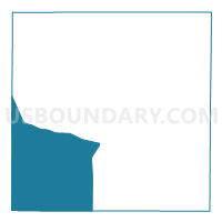
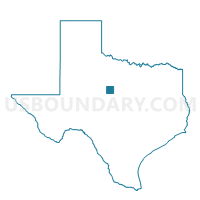
Voting District 0007, Callahan County, Texas
About
Outline

Summary
| Unique Area Identifier | 671292 |
| Name | Voting District 0007 |
| County | Callahan County |
| State | Texas |
| Area (square miles) | 151.99 |
| Land Area (square miles) | 151.83 |
| Water Area (square miles) | 0.16 |
| % of Land Area | 99.89 |
| % of Water Area | 0.11 |
| Latitude of the Internal Point | 32.16489480 |
| Longtitude of the Internal Point | -99.53154370 |
Maps

Graphs
Select a template below for downloading or customizing gragh for Voting District 0007, Callahan County, Texas


Neighbors
Neighoring Voting District (by Name) Neighboring Voting District on the Map
- Voting District 0001, Coleman County, TX
- Voting District 0002, Callahan County, TX
- Voting District 0004, Callahan County, TX
- Voting District 0004, Coleman County, TX
- Voting District 0006, Callahan County, TX
- Voting District 0408, Taylor County, TX
- Voting District 0409, Taylor County, TX
Top 10 Neighboring County Subdivision (by Population) Neighboring County Subdivision on the Map
- Abilene CCD, Taylor County, TX (118,774)
- Clyde CCD, Callahan County, TX (9,287)
- Jim Ned CCD, Taylor County, TX (7,269)
- Coleman CCD, Coleman County, TX (5,542)
- Baird CCD, Callahan County, TX (2,223)
- Cross Plains CCD, Callahan County, TX (2,034)
- Novice CCD, Coleman County, TX (728)
Top 10 Neighboring Place (by Population) Neighboring Place on the Map
Top 10 Neighboring Unified School District (by Population) Neighboring Unified School District on the Map
- Wylie Independent School District, TX (17,733)
- Clyde Consolidated Independent School District, TX (12,567)
- Jim Ned Consolidated Independent School District, TX (5,629)
- Coleman Independent School District, TX (5,305)
- Eula Independent School District, TX (2,586)
- Baird Independent School District, TX (2,421)
- Novice Independent School District, TX (623)
Top 10 Neighboring State Legislative District Lower Chamber (by Population) Neighboring State Legislative District Lower Chamber on the Map
Top 10 Neighboring State Legislative District Upper Chamber (by Population) Neighboring State Legislative District Upper Chamber on the Map
Top 10 Neighboring 111th Congressional District (by Population) Neighboring 111th Congressional District on the Map
Top 10 Neighboring Census Tract (by Population) Neighboring Census Tract on the Map
- Census Tract 134.04, Taylor County, TX (7,527)
- Census Tract 135, Taylor County, TX (7,269)
- Census Tract 301.02, Callahan County, TX (4,543)
- Census Tract 302, Callahan County, TX (4,257)
- Census Tract 9506, Coleman County, TX (1,399)
Top 10 Neighboring 5-Digit ZIP Code Tabulation Area (by Population) Neighboring 5-Digit ZIP Code Tabulation Area on the Map
- 79602, TX (21,519)
- 79510, TX (7,982)
- 76834, TX (5,908)
- 79504, TX (2,787)
- 79541, TX (791)
- 76828, TX (199)
- 79519, TX (74)